Unmanned Aircraft and Photogrammetry in the Mining Space
With the emergence of new technology in the mining sector almost every day, it can be difficult to keep up.
For large companies, this can be made worse by the daily workload and onsite events, bureaucracy and conservative thinking. “We’ve always done it this way,” is a phrase we are all too familiar with.
But each of us can challenge the status quo.
If you told someone 20 years ago that we would eventually be able to use flying machines to autonomously take photos of a pit wall and develop 3D models in the space of a few hours, you would have been laughed out of the room.
These days it is somewhat considered best practice.
During the dawning years of Unmanned Aerial vehicle (UAV) data capture on mine sites, their use was restricted primarily to surveyors for their spatial pick-ups.
Today, we see people from a range of professions using UAVs – from environmental scientists to operation supervisors and drill and blast engineers.
Geotechnical engineers also use them in ways that might not immediately be apparent.
In order for us to make geotechnical assessments, a lot of work goes into developing a reliable dataset and realistic parameters. Part of this is the structural make-up of the wall – the fault lines and various joint sets that can cause failures and instability.
The synthesis of this information makes up what is called the Structural Model.
Collecting this data is not as easy as drawing lines on a photo, although that does have a time and place. In reality, it involves being able to make accurate, three dimensional measurements where structures are present, and being able to manipulate this data in space and visualise what is happening behind the face.
Historically, this would involve a team of people including surveyors, geotechnicians, geologists and field hands setting up various ground-based pieces of equipment to make measurements of these features. Quite an arduous task.
Today we employ the use of photogrammetry - a way of “stitching” together a number of photographs of an object or an environment and forming a model, to scale and in real space.
Traditionally this was done with ground-based cameras, however with the rise of remote-controlled aerial vehicles we can take this a step further. It significantly reduces the time it takes to complete a job and can capture crucial data from areas potentially considered unsafe for people on the ground.
As an example, say there is a complex wall failure on site causing the shutdown of a truck circuit. The shift supervisor has made the call that a geotechnical assessment is required before mining can resume.
The geotechnician can now drive out to the area, undertake a risk assessment, prepare their UAV, set a flight plan (or manually fly), capture the data they need, and bring it back to the office for data processing before they can make a call on whether it is safe for mining to continue.
With this technology, a job that in the past would have been time intensive and involved liaising between several parties can now be done in quick turnaround by a single person.
Though a large number of operations are adopting UAV technology, some have not yet harnessed its full potential. Site geotechnical engineers may, as previously mentioned, be stuck in their existing workflow and need that extra push to work outside of their normal realms.
Though originally a high-priced endeavour, the cost of these UAV systems is decreasing as the technology becomes more common across the industry.
Software packages now form the most expensive portion, with some making up 90% of the total cost. However, the benefits that these tools provide pay dividends with their ease of use, multiple functionalities and quick turnaround from data capture to data interpretation and reporting.
Considering the ever-growing focus on production numbers, this technology allows us to efficiently capture this data. More importantly, though, it allows us to capture it remotely, which is safer as the operator is isolated from harmful areas in the mine site.
This article appeared in the September 2020 edition of the Australian Resources & Investment magazine.
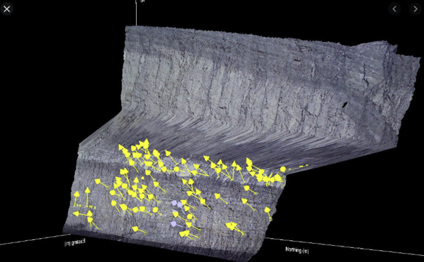
3D model created from photogrammetry (google)

DJI Phantom 4 RTK (google)
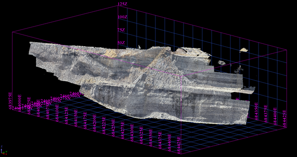
3D photogrammetry model (created in office using Surpac software)